Weather
Temperatures required to kill corn plants
Freezing temperatures before physiological maturity can damage corn. Maturity in corn occurs when kernels form a black layer at the kernel tip, grain will be at approximately 30 to 35 percent moisture. After maturity, no additional dry matter will be accumulated in the seed. In addition to creating quality problems, premature frost will reduce the yield of dry grain.
Corn is killed when temperatures are near 32 F for a few hours, and when temperatures are near 28 F for a few minutes (Carter and Hesterman, 1990). A damaging frost can occur when temperatures are slightly above 32 F and conditions are optimum for rapid heat loss from the leaves to the atmosphere, i.e. clear skies, low humidity, no wind. At temperatures between 32 to 40 F, damage may be quite variable and strongly influenced by small variations in slope or terrain that affect air drainage and thermal radiation, creating small frost pockets. Field edges, low lying areas, and the top leaves on the plant are at greatest risk. Greener corn has more frost resistance than yellowing corn.
Symptoms of frost damage will start to show up about 1 to 2 days after a frost. Frost symptoms are water soaked leaves that eventually turn brown. Because it is difficult to distinguish living from dead tissue immediately after a frost event, the assessment should be delayed 5 to 7 days.
Source: University of Wisconsin
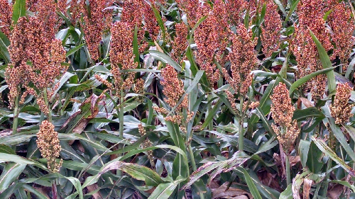
How an early freeze affects grain sorghum
A light freeze may kill the leaves, but the grain may continue to fill until the stalk dies. Death does not occur until the stalks have been frozen, breaking the flow of nutrients to the grain.
Freeze damage lowers the test weight of grain sorghum. In general, the less developed the sorghum is at the time of the killing freeze, the lower its test weight. Low test weights of combine harvested, freeze-damaged grain sorghum are due primarily to high levels of foreign material and broken kernels. A killing freeze prior to maturity stops the growth of the seed, creating small, lightweight grain, which may be shriveled and difficult to thresh. Signs of freeze damage include watery patches on plant leaves, followed by necrotic white lesions on the affected area.
Source: K-State

Assessing frost damage in soybeans
Soybean tops are easily damaged by frost in the 30 F to 32 F range. Temperatures under 30 F for any extended period of time can completely kill soybean plants (stems and leaves). Generally speaking, the soybean fields planted to narrow row spacing (6-7 inches to 15 inches), may have slightly more tolerance to light frosts than soybeans planted in wider rows (30-36 inches). Also soybean plant populations that have thin stands are more affected and injured by frost.
Source: North Dakota State University
Factors in wind erosion potential on sparsely covered soil
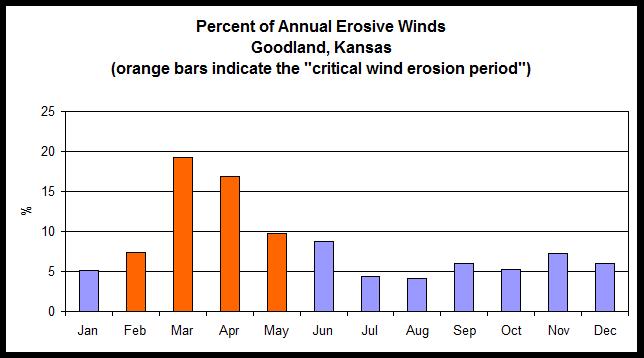
Some wheat stands, especially in parts of western Kansas, are thin or poorly developed this year due to dry conditions. This increases the potential for wind erosion during the winter and early spring months, when wind erosion rates are often at their highest.

Source: John Tatarko, USDA-ARS Engineering and Wind Erosion Research Unit, Manhattan, Kansas
When vegetation is insufficient, ridges and large soil clods (or aggregates) are frequently the only means of controlling erosion on large areas. Roughening the land surface with ridges and clods reduces the wind velocity and traps drifting soils. A cloddy soil surface will absorb more wind energy than a flat, smooth surface. Better yet, a soil surface that is both ridged and cloddy will absorb even more wind energy and be even more effective in reducing the potential for wind erosion.
Soil crusts and frozen ground also can increase resistance of the surface soil to wind forces, but this effect is only temporary and should not be relied on for erosion control.
Crosswind ridges are formed by tilling or planting across the prevailing wind erosion direction. If erosive winds show no seasonal or annual prevailing direction, this practice has limited protective value. In Kansas, the prevailing winds in the winter are from the north, and in early spring the prevailing winds are from the south. Crosswind ridges at this time of year, therefore, should be in an east-west direction to protect from both northerly and southerly winds.
|
Month
|
Prevailing Wind Erosion Direction, Goodland
|
| January |
NNW |
| February |
NNW |
| March |
NNW |
| April |
NNW |
| May |
SSE |
| June |
S |
| July |
SSE |
| August |
SSE |
| September |
S |
| October |
NNW |
| November |
NNW |
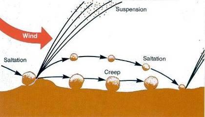
Tillage implements can form ridges and depressions that alter wind velocity. The depressions also trap saltating soil particles and stop avalanching of eroding material downwind.

However, soil ridges protrude higher into the turbulent wind layer and are subject to greater wind forces. Therefore, it is important that cloddiness on top on the ridge is sufficient to withstand the added wind force, otherwise they will quickly erode, and the beneficial effects will be lost. Ridging sandy soils, for example, is of little value because the ridges of sand are erodible and soon leveled by the wind.
Clod-forming tillage produces aggregates or clods that are large enough to resist the wind force and trap smaller moving particles. They are also stable enough to resist breakdown by abrasion throughout the wind erosion season.
If clods are large and stable enough, as smaller particles are removed or trapped, the surface becomes stable or "armored" against erosive action. The duration of protection depends on the resistance of the clods to abrasion or changes in the wind direction.
Of the factors that affect the size and stability of soil aggregates, most notable is soil texture. Sandy or coarse-textured soils lack sufficient amounts of silt and clay to bind particles together to form aggregates. Such soils form a single-grain structure or weakly cemented clods, a condition that is quite susceptible to erosion by wind. Loams, silt loams, and clay loams tend to consolidate and form stable aggregates that are more resistant to erosive winds. Clays and silty clays are subject to fine granulation and more subject to erosion.
Many other factors also affect aggregate consolidation and stability — climate, including moisture; compaction; organic matter; lime; microorganism activity; and other cementing materials.
Any process that reduces soil consolidation also increases erodibility. The persistence of aggregates is greatly affected by the climatic process of wetting and drying, freezing and thawing, or freeze-drying, which generally disintegrates clods and increases erodibility.
Mechanical action, such as tillage, animal or machine traffic, and abrasion by saltating soil particles also can affect cloddiness. Tillage may either increase or decrease clods at the surface, depending on the soil condition in the tilled layer and the type and speed of the implement. Repeated tillage usually pulverizes and smooths dry soils and increases their erodibility, especially if done with implements that have an intensive mechanical action, such as tandem disks, offset disks, or harrows.
Soil water at the time of tillage also has a decided effect on cloddiness. Research has found that different soils have differing water contents at which soil pulverization is most severe. If the soil is extremely dry or extremely moist, smaller clods are produced than at intermediate water contents.
-- John Tatarko, Soil Scientist, USDA-ARS
-- DeAnn Presley, Soil Management Specialist
Emergency measures to control wind erosion
Cropland can be quite susceptible to wind erosion under some conditions. A particularly serious hazard is created when crop residues are burned or removed for forage. Winter wheat and other fall-planted crop fields may also be susceptible during periods of low cover in the winter and early spring.
This is particularly true after a drought year or after other crop failures, and this is the case in many areas of Kansas this year. Marginally productive cropland may not produce sufficient residue to protect against wind erosion. In addition, overgrazed or poorly vegetated rangeland may also subject to wind erosion.

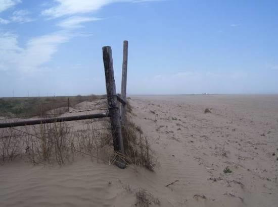
Field in southwest Kansas with major wind erosion damage. Photo by DeAnn Presley, K-State Research and Extension.
It is important to monitor field conditions and identify fields that are in a condition to blow. Such conditions include low vegetation cover and a high proportion of erodible-sized clods (less than 1 mm in size, or about the thickness of a dime). It is better to be proactive and treat potential problems before they occur than to try to react and catch up once a field is actively eroding. Once soil movement has started, it is difficult to completely stop further damage. However, prompt action may prevent a small erodible spot from damaging an entire field or adjacent fields.
* Mulching.
If wind erosion has already started, it can be reduced by mulching with manure or other anchored plant materials such as straw or hay. To be effective, at least 1.5 to 2 tons per acre of straw or grass or 3 to 4 tons per acre of corn or sorghum stover are needed to control areas of erosion, and the straw or hay must be anchored. Residue can be spread by hand, spreader or other mechanical equipment.
A stubble puncher or disk set straight may be used to anchor residue and prevent it from being blown away. Wet manure application should be 15 to 20 tons/acre and not incorporated into the soil. Care should be taken to not add wheel paths parallel to the wind direction as the mulch is applied. Traffic areas and wheel paths can contribute to wind erosion.
Generally, mulches are practical only for small areas, so mulching is most effective when applied before the soil starts to move. Producers should scout fields to identify areas that might be susceptible to wind erosion (low vegetation cover and a high proportion of erodible-sized clods less than the thickness of a dime) if they plan to use mulch or manure to controls.
* Emergency Tillage.
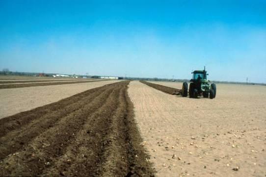
Emergency tillage is a last-resort method that can be effective if done promptly and with the right equipment. The goal of emergency tillage is to make the soil surface rougher by producing resistant clods and surface ridges. A rough surface reduces wind speed. The larger clods and ridges resist movement and provide traps to catch the moving soil particles.
Chisels with single or only a few tool ranks are frequently used to roughen the soil surface. The combination of chisel point size, speed, and depth that produces the roughest surface with the most firm, resistant clods should be used for emergency tillage.
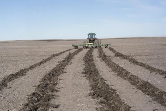
Research has shown that a narrow chisel (2 inches wide) on 24- to 54-inch spacing, operated 3 to 6 inches deep will usually bring enough resistant clods to the surface to control erosion on fine-textured (clay-based) soils. A medium shovel (4 inches wide) can be effective for medium-textured soils (loamy soils). Spacings should typically be narrower where there is no cover and wider in areas of partial cover, such as a growing crop or plant residue.
If the erosion conditions recur or persist, a second, deeper chiseling should split the first spacing. Tillage passes should be made perpendicular to the direction of the prevailing wind causing the erosion.

Emergency tillage across 50 percent of the field. Photo courtesy of USDA-ARS Engineering and Wind Erosion Unit, Manhattan, Kansas

Widely spaced shanks used for emergency tillage, making clods to roughen the soil surface. Photo courtesy of University of Nebraska.
If emergency tillage is to be used in growing crops that are covered by crop insurance, producers should check with their crop insurance providers regarding emergency tillage insurance rules. Emergency tillage does not significantly reduce wheat yields of an established crop. Studies in southwest Kansas and Manhattan demonstrate that the use of a chisel on 40-inch spacing reduced wheat yields by 5.5 bushels per acre on the emergency tillage area, due to direct injury caused by the tillage action. Since the entire field is rarely tilled when performing emergency tillage, the overall yield reduction for the field will be less than 5.5 bushels per acre. In fact, yields in the untilled portion of the field actually can be increased by the use of emergency tillage since that tillage will reduce the amount of damage to wheat caused by wind erosion. The overall reduction in yield for fields that have received emergency tillage has been as little as 1 bushel per acre in the studies mentioned above.
Performing emergency, clod-forming tillage across the field is effective in reducing wind erosion. The degree of success of emergency tillage is highly dependent on climatic, soil, and cover condition. It is often not necessary to till the entire field, but rather, it is very effective to perform emergency tillage passes across 50% of the field (till a pass, leave a pass, repeat). Narrow chisel spacing (20 to 24 inches) is best for this method.
If 50% of the area has been tilled and wind erosion persists, the omitted strips can be emergency-tilled in a second operation to make result in full-cover tillage. If a second tillage pass is needed, it should be at a greater depth than the first pass. Wide chisel spacings are used in the full-field coverage method. The space between chisel grooves can be chiseled later should wind erosion persist.
All tillage operations should be perpendicular or across the direction of the prevailing or eroding wind. For most of Kansas, this means that an east-west direction of tillage is likely best.
The best wind erosion control is created with maximum surface roughness when resistant clods cover a major portion of the surface. Research shows that lower travel speeds of 2 to 3 mph generally produce the largest and most resistant clods. However, speeds of 5 to 7 mph produce the greatest roughness. Because clod resistance is usually reduced at higher speeds, the effect may not be as long-lasting as at lower speeds. Thus, higher speeds are recommended where erosion is already in progress, while lower speeds might be a better choice in anticipation of erosion.
Depth of tillage usually affects clod stability more than travel speed, but optimum depth is highly dependent on soil conditions (such as moisture level) and compaction. Deeper tillage passes can produce more resistant clods than shallow passes.
If the problem is severe and the wheat has already been destroyed or the ground is bare, chisels 4 to 6 inches wide on a 24- to 30-inch spacing will generally provide enough clods to control erosion. Operating depth should be 4 to 6 inches.
Loose sandy soils require a different tillage approach to effectively control erosion. Clods cannot be formed at the surface that will be sufficiently resistant to erosion on sandy soils. Erosion resistance is achieve through building ridges and furrows in the field to provide adequate protection.
A 14-inch moldboard lister spaced 40 to 50 inches apart (or an 8-inch lister on 20- to 24-inch spacing) is needed to create sufficient surface roughness. The first listing pass should be shallow, not more than about 4 to 5 inches deep. Then, when additional treatment is needed, the depth should become progressively deeper. Alternatively, for the second treatment the original ridge may be split.
The addition of manure to the ridged surface may also be beneficial in these situations.
* Watch the weather forecast for periods of high winds, particularly when soils are dry.
* Assess residue and plant cover prior to the wind blowing, and take preventive action with emergency tillage. It is much easier to prevent the problem from starting than to stop erosion after it begins. If you wait, the soil only gets drier and some moisture is needed to form clods.
* Use the combination of tractor speed, tillage depth, and chisel point size that will produce the roughest surface with the most resistant clods. If wind erosion is anticipated, do some test tillage prior to an erosion event to see what tillage tool, depth, and speed will provide adequate clods and surface roughness.
* Always start at the upwind location when the field is blowing. A sufficient area upwind of the eroding spot should be tilled, in addition to the area presently blowing.
* Till in a direction perpendicular to the prevailing wind direction. For row crop areas it may be necessary to compromise direction and follow the row pattern. Maintain as much anchored stubble in the field as possible.
-- DeAnn Presley, Soil Management Specialist
-- Peter Tomlinson, Environmental Quality Specialist
Weather for October Across Kansas and in Our Area
October was quite the month for our area! Across Kansas, October was below-normal in both temperature and precipitation. There was little change in the overall drought conditions in Kansas.
According to the K-State climatologist, there were 18 new record daily high temperatures this month and 66 new record cold high temperatures across the state. The highest temperature was 95 degrees at Atwood on October 4. Across the state, this was the 15th coldest October on record. However, due to the exceptionally warm spring, the January through October period still ranks as the warmest on record.
At the National Weather Service in Goodland, the highest temperature was recorded on October 3 at 90 degrees. The lowest was 20 degrees on October 27. The average monthly high is 50 degrees and that is 1.9 degrees below average. It is a bit interesting that October seems to be a bit confused on when it was supposed to be warm and when it was supposed to be cold! At the beginning of the month, on October 5 and 6, the temperature average was 22 degrees below normal. On October 30 and 31, the average temperature was 11 degrees above normal.
For the precipitation, the state climatologist stated that the preliminary state wide average precipitation was 1.12 inches. This is 58% of normal. This makes it the 25th driest October on record in Kansas since 1895. On 10 days no measurable precipitation was seen in the state. On 14 days the statewide average was one hundredth of an inch or less, with only isolated reports of moisture. Only one day had a statewide average greater than half an inch.
At the National Weather Service in Goodland, the monthly rainfall for October was 0.41 inches. This was 0.96 inches below normal. The most rainfall fell on October 6 with 0.16 inches. All other rainfall events were less than 0.10 inch. According to the K-State climatologist, the latest Drought Monitor showed the entire state in severe drought or worse. Extreme drought now covers 77.8 percent of the state, with nearly 40 percent of the state in exceptional drought. Given the lack of rain over the last several weeks, the area of extreme drought is likely to expand, particularly in eastern Kansas which typically sees more precipitation in November than the western areas of the state.
The latest Drought Outlook indicates drought conditions are expected to continue through January. The expected El Niño has failed to develop, and neutral conditions are expected to persist through the winter. That means the signal for increased winter precipitation will also be weaker. For November, chances for precipitation are equally likely for above or below normal in the western half of the state, with slightly greater chances for below normal precipitation in the east. Temperatures are expected to be normal in all except the eastern areas of the state, where the outlook calls for equal chances of above or below normal temperatures.
